Choosing America’s most transformative hikes isn’t easy. Every trail offers something unique—glacier views, desert hoodoos, or wildflower meadows. Some paths even change lives, inspiring moves into vans or commitments to thru-hiking.
This list focuses on the Lower 48 states to highlight diverse landscapes without overshadowing Alaska and Hawaii. From granite peaks to swampy wetlands, each hike blends accessibility with ecosystem protection.
Barry Lopez’s philosophy shines here. Nature-driven wonder rewires perspectives. Whether standing above clouds on Haleakalā or navigating slot canyons in Utah, these trails deliver awe.
Table of Contents
Key Takeaways
- Trails range from easy walks to challenging climbs.
- Focus on Lower 48 states ensures diversity.
- Hikes protect ecosystems while remaining accessible.
- Landscapes include deserts, mountains, and forests.
- Inspiration comes from nature’s transformative power.
Introduction to America’s Most Stunning Trails
America’s trails offer more than just steps—they spark life-changing journeys. From the Grand Canyon’s depths to the Pacific Crest Trail’s peaks, each experience reshapes perspectives. This guide celebrates hikes that blend adventure with introspection.

Selecting the best hikes is subjective. Some prioritize solitude, like Arkansas’ Ozark Highlands, while others seek challenges like California’s John Muir Trail. Three criteria guided our picks:
- Transformative impact: Trails that inspire van life or career shifts.
- Lower 48 focus: Highlights diversity without excluding Alaska or Hawaii.
- Non-secret status: Protects ecosystems by promoting established routes.
With hikes in all 50 states, we’ve seen how landscape alters lives. Barry Lopez’s idea of nature-driven wonder rings true here—whether navigating Utah’s slot canyons or Quebec’s Le Fjord Trail.
| Trail | Transformative Feature | State |
|---|---|---|
| Grand Canyon Rim-to-Rim | Perspective shift | Arizona |
| Pinhoti Trail | Community connection | Alabama |
| Teton Crest Trail | Alpine solitude | Wyoming |
Promoting these trails comes with responsibility. Travel sustainably—stick to marked paths and support local conservation efforts. Ready to explore? The next sections detail trails that deliver awe without compromising nature’s balance.
Black Elk Peak: South Dakota’s Hidden Gem
Rising above South Dakota’s Black Hills, Black Elk Peak delivers adventure and cultural depth. At 7,242 feet, it’s the highest point east of the Rockies, with routes winding through granite spires and stone staircases.

Trail Details: Length, Duration, and Elevation
The Black Elk Peak Loop Trail spans 7.1 miles with a 1,469-foot elevation gain. Shorter 5-mile options start at Sylvan Lake, while longer routes like Willow Creek Loop offer solitude.
| Route | Distance | Features |
|---|---|---|
| Sylvan Lake Trail No. 9 | 7 miles | Stone tower summit |
| Willow Creek Loop | 10 miles | Wildlife sightings |
| Cathedral Spires Trail | 3 miles | Granite formations |
Why It’s Unforgettable: Views and History
From the summit, five-state views unfold beside a historic fire lookout tower built in the 1930s. The Lakota name hinhan kaga reflects its sacred role in Black Elk’s vision.
Pro Tip: Skip Mount Rushmore for This Summit
Unlike crowded Mount Rushmore, this trail balances awe with tranquility. Post-hike, dive into Sylvan Lake or spot bison in Custer State Park.
Coyote Buttes North: The Wave in Arizona
Arizona’s Coyote Buttes North hides one of nature’s most surreal masterpieces—The Wave. This desert trek rewards hikers with swirling sandstone formations that look painted by giants. But getting there requires planning—and luck.

Permit Requirements and How to Secure One
Only 48 daily permits are issued via a competitive BLM lottery. Here’s how to boost your odds:
- Apply early: Submissions open four months ahead, with a $9 fee.
- Consider a guide: For $575/person, pros navigate tricky terrain like Top Rock.
- Backup plan Coyote Buttes South has similar geology with fewer crowds.
Geologic Wonders Beyond The Wave
The 6-mile round-trip trail unveils more than Instagram-famous curves. Near the “dance floor,” 200-million-year-old dinosaur tracks fossilize the sandstone. Further exploration reveals Melody Arch and the Second Wave’s crossbedded layers.
Pro tip: Pair your hike with Wire Pass Slot Canyon for narrow passages and shaded ledges. Just pack extra water—this desert demands respect.
The First 30 Miles of the Florida Trail
Florida’s wild side comes alive along the first 30.6 miles of its iconic trail. Stretching from Oasis Visitor Center to I-75, this segment immerses hikers in cypress domes and panther territory. Wading through knee-deep water and spotting air plants redefine adventure.

Swamps, Wildlife, and Unique Challenges
Alligator-inhabited waters demand cautious steps. Tropical hardwood hammocks shelter wild orchids, while pitcher plants dot the Blackwater section. Navigation relies on orange blazes—critical in Eglin’s steep ravines.
Rare sightings include Florida panthers and invasive pythons. The Econfina segment adds pitcher plant bogs, testing endurance. Compared to Royal Palm’s Anhinga Trail, this route rewards seasoned hikers.
Best Time to Hike and Safety Tips
Winter avoids hurricanes and swarming insects. Pack a sawyer filter—water sources often need treatment. Key logistics:
- Distance: 30.6 miles split into manageable legs (e.g., 13.8-mile Oasis to 7 Mile Camp).
- Wildlife: Store food securely; panthers roam at dawn.
- Navigation: Blazes fade; carry a backup map.
This stretch proves Florida’s trail isn’t just sand—it’s a biodiverse gauntlet.
Franconia Ridge Loop: New Hampshire’s Alpine Wonder
New Hampshire’s White Mountains hide a ridge trail that rivals Western vistas. The Franconia Ridge Loop blends East Coast accessibility with rugged alpine terrain. This 9-mile loop trail climbs 3,800 feet, delivering jaw-dropping panoramas above the treeline.

Why This Trail Feels Like a Mountain Playground
Walking the exposed ridge feels like stepping onto a natural tightrope. For over a mile, hikers traverse alpine tundra with 360-degree views of Mount Lafayette and beyond. Delicate diapensia plants dot the path—some take 50 years to grow here.
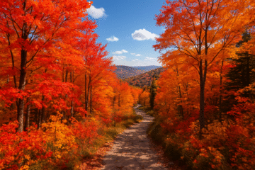
Ecological zones shift dramatically. Start in maple forests, ascend through stunted krummholz, then emerge onto wind-swept granite. Summer brings wildflowers, while fall paints the slopes fiery orange.
Alternate Routes for Shorter Adventures
Not ready for the full loop? Try these variations:
- Old Bridle Path: A 5-mile alternative with fewer crowds but steeper descents.
- AMC Greenleaf Hut: Break at this mountain lodge halfway up.
- Mount Washington Auto Road: Drive partway for a condensed experience.
Weather changes fast here. Check Mount Washington Observatory updates before heading out. Pack layers—temperatures can drop 30°F atop the mountain.
This loop trail proves you don’t need Rockies elevation for breathtaking alpine adventure. Just bring sturdy boots and a sense of wonder.
The Grand Canyon: Rim-to-Rim Adventure
No hike reshapes perspectives quite like crossing the Grand Canyon rim-to-rim. This 20–30-mile trek stitches together towering cliffs, ancient rock layers, and the lifeblood of the Colorado River. Whether you sprint it in a day or savor it over days, the journey etches itself into memory.
Logistics: Starting Points and Duration
The classic route drops 5,761 feet from North Kaibab to South Kaibab, then climbs 4,380 feet back up. Most tackle it in 2–4 days, though elite hikers finish in under 12 hours.
Key stops include Phantom Ranch, where cabins book a year ahead. Permits open four months early—plan like a pro. Temperature swings? Expect 80-degree shifts between rim and river.
How This Hike Changes Your Perspective
Walking the canyon’s spine reveals Earth’s story. The Great Unconformity shows 1.2 billion years missing from rock layers. At the bottom, the river corridor blooms with cottonwoods, a shock of green in the desert.
One 2015 thru-hiker described it as “time travel with blisters.” The experience sticks—whether you’re dodging heat at Devil’s Corkscrew or gasping at Ooh Aah Point’s sunset.
- Single-day vs. multi-day: Speed demons risk heatstroke; slowpacks savor Phantom Ranch’s lemonade.
- Gear musts: Trekking poles for steep grades, electrolyte tabs for 130°F heat indices.
- Alternate routes: Bright Angel Trail adds water stops but crowds.
Longs Peak: Colorado’s Iconic 14er
Colorado’s skyline wouldn’t be complete without Longs Peak’s jagged silhouette. This mountain towers at 14,259 feet, challenging hikers with its legendary Keyhole Route. Only half who attempt it reach the summit—a testament to its rugged terrain.
Keyhole Route: Thrills and Challenges
The 14-mile trail starts pre-dawn to avoid afternoon storms. Dark rock bands mark the route, leading to technical sections like the Trough’s steep scrambles. The Narrows’ exposed ledges demand focus—one misstep could be fatal.
Front Range weather shifts fast. Sudden lightning or snow isn’t uncommon, even in summer. Pack layers and check forecasts twice before heading out.
Acclimatization Tips for Beginners
Altitude sickness hits hard above 10,000 feet. Spend 2–3 days in Estes Park to adjust. Try Quandary Peak first—it’s a gentler 14er with similar elevation.
- Hydrate: Drink twice your usual water intake.
- Pace yourself: Slow steps prevent exhaustion.
- Watch for wildlife: Bighorn sheep often graze near Chasm Lake.
Post-hike, celebrate with pizza in Estes Park. You’ve earned it after conquering Colorado’s crown jewel.
Lost Coast Trail: California’s Untamed Shoreline
Where Highway 1 ends, the real coastal adventure begins. The Lost Coast trail stretches 25 miles through Northern California’s most rugged shoreline, bypassing roads with landslide-prone cliffs. Unlike tourist-heavy Redwood parks, this route demands self-sufficiency and tide charts.
Timing is everything. High tides swallow entire beach sections, making NOAA charts essential for safe passage. Most hikers complete the route in 3-5 days, camping where creeks meet the sea.
King Range’s geology creates a wildlife corridor. Roosevelt elk herds roam the bluffs, while elephant seals bask on isolated coves. Keep bear canisters visible—they’re mandatory and available for $5 at the King Range Visitor Center.
- Best campsites: Spanish Flat offers wind protection; Miller Flat has freshwater access
- Seasonal tips: June-October bans fires but brings clearer skies
- Gear musts: Waterproof boots for stream crossings and marine fog
Compared to Redwood National Park’s crowds, this coast delivers solitude. Just pack layers—the same fog that hides the trail also chills summer nights to 50°F.
Mount Rainier National Park: Burroughs Mountain Trail
Few trails bring you face-to-face with glaciers like Mount Rainier’s Burroughs Mountain. This 9-mile loop climbs to the park’s highest hikable point, where icy giants like Emmons Glacier dominate the horizon. Prepare for thin air, wildflower meadows, and marmots whistling from rocky outcrops.
Glacier Views and Seasonal Challenges
The trail’s northern stretch skirts Emmons Glacier, offering 360-degree views of its crevassed expanse. July and August paint the slopes with lupine and paintbrush, but early-season hikers should pack microspikes for lingering snowfields.
At 2,500 feet of elevation gain, fitness matters. Pace yourself—the thin air hits hard above 7,000 feet. Sunrise transforms the mountain into a photographer’s dream, with alpenglow illuminating the glacier’s blue cracks.
Wildlife and Crowd Comparisons
Pikas chirp from talus slopes, while marmots sunbathe near meltwater pools. Unlike the packed Skyline Trail, Burroughs Mountain offers solitude—just you, the wind, and Mount Rainier’s shadow stretching across the tundra.
- Best time to go: Mid-July for wildflowers, September for crisp air.
- Gear tip: Trekking poles stabilize loose scree on the descent.
- Hidden perk: Spot elk herds at dawn near Frozen Lake.
Haleakalā National Park: Hawaii’s Sky-High Sunrise
Watching dawn break from Haleakalā’s summit feels like standing on another planet. This national park offers a sunrise experience unmatched anywhere in Hawaii, with reservations required for the 3:00-7:00 am viewing window.
The summit’s lunar landscape shelters rare silversword plants. These spiky ‘āhinahina grow only here, taking 20-90 years to bloom before dying.
Prepare for extreme weather shifts. Temperatures swing from 30°F at dawn to 65°F by midday—pack gloves, windbreakers, and thermal layers.
| Option | Distance | Highlights |
|---|---|---|
| Drive to Summit | 38 miles round-trip | Quick access, parking limited |
| Halemauu Trail Hike | 11 miles | Crater views, fewer crowds |
Hawaiian legends say demigod Maui lassoed the sun here. The sacred site still hosts traditional ceremonies at dawn.
Pair your visit with the Pipiwai Trail’s bamboo forests and 400-foot Waimoku Falls. Full moon hikes reveal the crater’s silver glow—permits sell out fast.
This experience transcends typical vacations. Where else can you watch clouds form beneath your feet as the sun paints the Pacific gold?
Angel’s Landing: Zion’s Daredevil Hike
Chain-assisted climbs and sheer drops define Angel’s Landing’s adrenaline rush. This 5-mile trail in Zion Park ascends 1,500 feet via carved steps and bolted chains. Since 2022, a permit system manages crowds on its vertigo-inducing spine.
Navigating the Permit Lottery
Secure access via Recreation.gov’s seasonal lottery. Key details:
- Spring-Fall: $6 application fee for 1-6 person groups
- Last-minute: Day-before lottery releases 40 additional permits
- Off-season: No permits needed November-February
Geology and Trail Features
The route crosses Navajo Sandstone, formed 150 million years ago. Walter’s Wiggles—21 switchbacks carved in the 1920s—lead to the final half-mile. Chains guard exposed sections with 1,000-foot drops.
California condors often circle overhead. Their 9-foot wingspan dwarfs hikers clinging to the rock walls.
Safety First: Know the Risks
At least 13 fatalities occurred since 2000, often from slips or cardiac events. Avoid crowding on narrow sections—human traffic jams increase danger.
| Trail | Distance | Best For |
|---|---|---|
| Angel’s Landing | 5 miles | Thrill-seekers, sunrise views |
| Observation Point | 8 miles | Families, panoramic photos |
Prefer tamer views? Observation Point’s 8-mile route delivers comparable vistas without chains. Start before 6am to beat heat and crowds—pack 3L water per person.
Essential Gear for Hiking the U.S.’s Best Trails
Smart preparation separates memorable hikes from survival situations. The right equipment adapts to terrain—whether crossing Florida’s swamps or Grand Canyon’s arid plateaus. This guide covers must-haves for comfort and safety.
Footwear, Layers, and Must-Have Accessories
Terrain dictates footwear. Chacos sandals drain swamp water, while Salomon’s XA Pro 3D GTX shoes grip granite with women-specific models available. Merino wool socks prevent blisters during multi-day treks.
Layering systems combat changing conditions:
- Base: Smartwool tops wick sweat in cold weather
- Mid: Patagonia Nano Puff Hoody uses PrimaLoft Gold insulation
- Shell: GoreTex jackets block rain yet breathe
Osprey’s Mira packs (22L, 32L) carry essentials with hydration bladders for easy water access. Don’t forget:
| Item | Purpose |
|---|---|
| Buff neck gaiter | Sun/wind protection |
| Garmin Epix Gen 2 watch | GPS elevation tracking |
| Paper Cairns maps | Backup navigation |
Water and Food: Planning for Long Treks
Florida’s humid trails demand sawyer filters, while Grand Canyon hikes require Nuun electrolyte tablets. Follow the 1L per 2-hour rule, doubling for desert routes.
Calorie-dense foods fuel endurance:
- Breakfast: Oatmeal with nuts (Thermos keeps hot)
- Snacks: Trail mix, peanut butter packets
- Dinner: Dehydrated meals (600+ calories)
Bear canisters protect food in King Range, while PCT hangers work elsewhere. Pack these ten essentials:
- Emergency shelter (bivy/tarp)
- Firestarter and matches
- First aid kit with moleskin
With proper gear, every trail becomes an achievable experience. Adjust kits seasonally—swap gloves for sunscreen when needed.
Safety Tips for Tackling America’s Toughest Hikes
Preparation separates exhilarating hikes from dangerous situations. Whether facing desert heat or alpine storms, smart planning ensures you return with stories rather than scars.
Weather Wisdom for Every Environment
Above treeline on trails like Franconia Ridge, lightning becomes a real threat. Descend immediately when thunder rolls—summits aren’t worth the risk.
Desert hikes demand early starts. On the Grand Canyon’s South Kaibab Trail, temperatures can spike 30°F by noon. Carry electrolyte tabs and recognize heat exhaustion signs.
Wildlife Encounters Done Right
Black bears roam from the Smokies to Yosemite. Make noise on blind curves, store food properly, and know how to use bear spray. For moose or panthers, give 50+ feet of space and never block escape routes.
Learn more about wildlife safety protocols for different regions.
Emergency Essentials That Save Lives
- Shelter: Compact bivvy sacks weigh ounces but retain body heat
- Signaling: Mirrors and whistles carry farther than shouts
- Navigation: Paper maps work when electronics fail
Check hiking safety checklists before packing. A well-stocked kit makes all the difference when weather turns or injuries happen.
Smart Group Strategies
Four-person groups balance safety with mobility. Larger parties move slower but offer more resources if someone gets hurt. Always share your itinerary and return time with someone reliable.
Remember: The mountains don’t care about your plans. Flexibility and respect for nature’s power keep hikers safe in wild places.
The 10 Most Awesome Hikes in the U.S.: Final Thoughts
Wilderness trails shape perspectives in ways cities never can. From slot canyons to alpine ridges, each path offers a unique *experience* that lingers long after the hike ends.
Transformative Power of Nature
Trails like Zion’s Narrows or Mount Rainier’s Skyline don’t just test endurance—they rewire how we see our place in the world. Studies show immersion in wild spaces reduces stress and boosts creativity by 50%.
Start Small, Dream Big
Begin with accessible routes like Acadia’s Precipice Trail before tackling the Grand Canyon’s Rim-to-Rim. Gradual progression builds confidence and skills.
| Trail | Skill Level | Key Benefit |
|---|---|---|
| Angel’s Landing | Intermediate | Adrenaline + views |
| Lost Coast | Advanced | Solitude + coastal beauty |
| Black Elk Peak | Beginner | Cultural depth |
Protect What You Explore
Follow Leave No Trace principles: pack out trash, stay on marked paths, and respect wildlife. Parks like Glacier and Yosemite depend on visitor stewardship.
Plan seasonal adventures—wildflower blooms in spring, alpine meadows in summer, and golden aspens in fall. Each season paints these landscapes anew.
Combine multiple *best hikes* into epic road trips. Drive from Zion to Bryce, or link Smoky Mountain trails with Shenandoah’s peaks. The *country*’s diversity awaits.
These aren’t just walks—they’re chapters in your *life*’s adventure book. Lace up, step out, and let the trails transform you.
Conclusion
From cypress swamps to glacier-carved peaks, adventure awaits across diverse landscapes. Over 193,500 miles of trails crisscross the united states, offering everything from silent deserts to alpine meadows.
Start small—local paths build skills for iconic routes like Zion’s Narrows. Remember Leave No Trace principles to protect these wild spaces for future travelers.
Share your hiking stories online. Tag @NationalParkService for trail tips and inspiration. Ready to explore? Every trail promises a fresh perspective—if you take the time to listen.

0 Comments