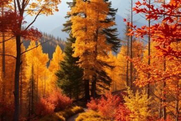
Arkansas hides breathtaking landscapes—towering bluffs, rushing rivers, and dense forests. But beneath this beauty lie trails that demand respect. I’ve spent years exploring the Ozarks and Ouachitas, where even seasoned hikers face unexpected challenges.
The Buffalo River region stands out, with its rugged terrain and sheer drops. Some paths here test your footing, while others reward you with unforgettable views. It’s not about avoiding these trails—it’s about tackling them wisely.
From waterfall risks to unstable bluffs, Arkansas offers adventures that thrill and humble. This guide shares six trails that push limits while emphasizing safety. With the right prep, every step becomes a story worth telling.
Table of Contents
Key Takeaways
- Arkansas’ trails combine stunning scenery with hidden risks.
- The Buffalo River area features some of the toughest paths.
- Proper preparation turns challenges into rewarding experiences.
- Terrain varies from steep bluffs to slippery waterfall crossings.
- Personal experience highlights the importance of caution.
Introduction to Arkansas’ Perilous Trails
Many assume Arkansas trails are gentle strolls—until they meet the Ozark Mountains’ hidden teeth. The state’s best hikes often disguise their risks behind waterfalls and wildflower meadows. After years exploring every trail here, I’ve learned complacency is the real danger.
Geology plays tricks here. Limestone erodes into deceptively smooth paths that crumble underfoot. Flash floods transform quiet creeks into torrents within minutes. The national river corridors, like the Buffalo, hide unstable bluffs behind their scenic views.
Seasonal changes rewrite the rules. A summer “easy” path becomes icy in winter, and spring rains slick rocks near waterfalls. In 2022, a fatal fall at Eye of the Needle reminded us all: elevation profiles don’t tell the full story.
Yet adventurers keep coming. The thrill of standing on a crumbling arch or spotting a hidden cave balances the risks. Just don’t underestimate these trails—proper footwear and weather checks are non-negotiable.
My advice? Study the area maps, pack extra water, and always tell someone your route. Arkansas rewards preparation with unmatched beauty—but only if you respect its wild heart.
1. Big Bluff and the Goat Trail: A Sheer Drop to Remember
Limestone crumbled under my boot as I inched along the Goat Trail’s six-inch ledge. Below, the Buffalo National River carved through the valley—550 feet straight down. This isn’t a trail for the faint-hearted; it’s a dance with gravity where one slip writes endings.

Trail Overview
The Centerpoint Trail is your gateway to Big Bluff, a 3-mile rocky path that descends toward the cliffside. At the end, the Goat Trail clings to the bluff face like a fraying ribbon. No railings. No second chances. Just panoramic views of Ponca Wilderness that steal your breath—and maybe your balance.
Risks and Challenges
That postcard-perfect limestone? It’s brittle. Footsteps loosen rocks, and sudden gusts test your stance. Last fall, I guided a trembling hiker back from the edge after their camera strap snagged on a bush—a reminder: Big Bluff forgives no distractions.
Summer tempts with river swims below, but scorching heat amplifies fatigue. Spring offers wildflowers but slick terrain. Autumn’s dry air? Your best shot at stable footing.
Safety Tips
Trekking poles are non-negotiable for the Centerpoint Trail’s descent. On exposed sections, practice the “three points of contact” rule (two hands + one foot always anchored). And those Instagram shots? Take them seated, legs crossed—never backward near the edge.
I’ve sat legs-dangling over that void, adrenaline humming. Respect the drop, and Big Bluff rewards you with Arkansas’ wildest high.
2. Hemmed-in Hollow Falls: Arkansas’ Tallest Waterfall
The roar of falling water echoed through the hollow long before I saw the cascade—209 feet of raw power. Hemmed-in Hollow Falls isn’t just a destination; it’s the tallest waterfall between the Rockies and Appalachians. Yet for most of the year, it’s a silent cliff, waiting for storms to awaken its fury.

Trail Overview
Reaching this giant requires grit. The Compton Trail’s 5-mile round trip tricks you with false summits before the final scramble over slick boulders. I learned the hard way: water shoes won’t cut it—their flimsy soles slide on algae-coated rocks. Alternatively, float the Buffalo River and hike upstream, but check with outfitters first. Rapids shift overnight.
Risks and Challenges
That serene name? A lie. After summer storms, Hollow Falls becomes a violent surge. Wind drives spray like needles, and debris—I once dodged a log the size of a couch. The plunge pool’s currents? Deceptively strong. Rangers have pulled stranded swimmers from its grip.
| Season | Risk | Reward |
|---|---|---|
| Spring | Flash floods | Thundering falls |
| Summer | Heat exhaustion | Swimming holes |
| Fall | Dry trails | Clear views |
Safety Tips
Pack rain gear even on sunny days—the hollow creates its own weather. For photography, a secret ledge above the falls exists, but it demands technical climbing skills. Heed this: if clouds gather, leave immediately. Evacuation here takes hours, and cell service vanishes like the water in drought season.
3. Whitaker Point (Hawksbill Crag): Iconic but Hazardous
Morning frost glazed the rocks like glass, a hidden danger at Arkansas’ most photographed cliff. Whitaker Point—better known as Hawksbill Crag—lures thousands with its sandstone ledge jutting over the Ozarks. But behind those Instagram posts lie risks most visitors never anticipate.

Trail Overview
The 3-mile trail Arkansas favorites winds through oak forests before revealing the crag. Sounds easy? Think again. That final approach narrows to a rocky spine with sheer drops on both sides. Last spring, I watched a hiker’s phone slide into the abyss—their grip faltered while adjusting a selfie stick.
Risks and Challenges
Crowds compound the danger. On weekends, bottlenecks force hikers to pass inches from the edge. And that hidden waterfall viewpoint? Its rocks stay slick year-round. Along way, I’ve seen:
- Black ice from overnight frost (even in April!)
- Erosion from shortcutters collapsing switchbacks
- Tourists leaning backward for photos, oblivious to wind gusts
| Time of Day | Risk | Solution |
|---|---|---|
| Sunrise | Icy rocks | Spiked shoe grips |
| Midday | Crowds | Weekday visits |
| Dusk | Fading light | Headlamps + early turnaround |
Safety Tips
Arrive by 5 AM to claim the ledge alone—and bring an emergency bivvy. If you must pass others, press against the cliffside, not the drop-off. Test every foothold; limestone crumbles like stale bread. And those epic sunset shots? Scout your angle early. Once light fades, retreat becomes a gamble.
Whitaker Point rewards the prepared with unmatched views. Just remember: that iconic ledge has no guardrails—or second chances.
4. The Eye of the Needle: Arkansas’ Most Dangerous Hike
My fingers dug into crumbling sandstone as the rope swung wildly—this was no ordinary hike. The Eye of the Needle isn’t just a trail; it’s a gauntlet of vertical climbs and hidden drop-offs. Even the National Park Service warns: “Only experienced climbers should attempt this route.”

Trail Overview
The 4.3-mile path starts innocently enough, winding through oak groves. Then, the earth tilts. You’ll face:
- A 15-foot rope ascent up a 45° rockface (gloves mandatory—I learned this after friction burns)
- Narrow ledges where sidestepping requires shuffling like a crab
- Three creek crossings that transform into rapids after rains
Kyle’s Landing road leads to the trailhead, but its potholes are the least of your worries.
Risks and Challenges
That “easy” creek crossing? Last spring, its undertow yanked my trekking pole into oblivion. False paths branch off toward sheer cliffs—I marked one with orange tape after a close call. Even in dry seasons, loose rocks mimic ball bearings underfoot.
Weather shifts fast here. When thunder boomed during my 2022 climb, evacuation time stretched to four hours. No cell service. No shortcuts.
Safety Tips
Pack like your life depends on it—because it might:
- Satellite communicator: Garmin inReach saved a stranded hiker last fall
- Leather gloves: Ropes fray quickly; synthetic fibers melt
- Tourniquet: Medics take hours to reach this ravine
This dangerous hike rewards the prepared with cathedral-like rock tunnels and panoramic views. But respect it—or join the 2022 fatality statistic.
5. Centerpoint Trail to Big Bluff: A Test of Nerve
Sunlight barely touched the jagged rocks as I began the steep descent—Centerpoint Trail wastes no time testing your legs. This 6-mile round trip packs 1,100 feet of elevation into relentless switchbacks. By mile two, my quads screamed louder than the hawks circling above.

Trail Overview
The trail big payoff comes at the halfway point—where limestone gives way to the Goat Trail’s exposed ledges. Morning hikers get cool breezes, but by noon, the rock formation becomes a heat trap. I learned to watch for lichen patterns—dark patches mean slippery, light ones offer grip.
False summits taunt you here. Just when you think it levels out, another drop appears. My trick? Rest at the three secure spots:
- A flat boulder with back support (mile 1.2)
- The lone pine with root handholds (mile 2.6)
- The overhang before the final descent (mile 2.9)
Risks and Challenges
That “shortcut” around the switchback? It’s a calf-shredding slide of loose scree. I took it once—spent twenty minutes picking gravel from my palms. The real danger hides in plain sight: the side trails that branch toward sheer drops.
Dusk arrives suddenly in the hollow. Last October, I misjudged the light and finished the return hike by headlamp—not an experience I’d recommend. The limestone becomes slick as wet soap when shadows lengthen.
Safety Tips
Electrolyte tabs saved me from cramps on this centerpoint big bluff trek. Plain water isn’t enough when you’re sweating buckets. For emergency slips, remember:
- Roll toward the wall, not the edge
- Dig heels in to slow slides
- Use backpack as a brake if needed
Calculate turnback time by doubling your ascent duration—if you hit the bluff in two hours, leave by 3 PM. This centerpoint big bluff route demands respect, but rewards with views that cling to your memory longer than the burn in your thighs.
6. Glory Hole Waterfall: Unique but Slippery
Raindrops fell through the circular gap above me—a natural skylight framing the Glory Hole’s cascading water. This isn’t just a waterfall; it’s a geological marvel where a creek plunges through a limestone borehole, carving a perfect circle over millennia. My first visit here taught me humility: moss turns rocks into ice, and “waterproof” boots fail without gaiters.

Trail Overview
The 1.8-mile section to Glory Hole starts gently, winding through hickory groves. Then, the way drops sharply into a ravine. Stepping stones lead to the grotto, where the waterfall pours through the ceiling like liquid light. After heavy rains, a second cascade appears—a secret even some locals miss.
Risks and Challenges
That emerald-green moss? It’s deceptively slick. I once watched a hiker slide five feet before catching a root. Upper cliffs shed debris—a walnut-sized rock gashed my pack last spring. Crowds compound dangers; too many cram onto the narrow ledge beneath the falls.
- Timing matters: Visit 24-48 hours after rains for full flow but safer footing.
- Test handholds: Limestone crumbles like stale cake—pull gently before committing weight.
- Descend sideways: Crab-walk down the grotto’s slope to avoid tumbles.
Safety Tips
This guide’s hard-won advice: wear approach shoes, not hiking boots—their sticky rubber grips wet rock better. Pack a microfiber towel; mist soaks everything. And never climb the fragile rim. Rangers have hauled back too many who thought, “Just one more step for the shot.”
Glory Hole belongs on every hikes Arkansas bucket list. But respect its whims—this waterfall dances to nature’s rhythm, not yours.
Conclusion: Hike Smart in Arkansas’ Wild Terrain
The moment my boot slipped on wet sandstone near Hemmed-in Hollow, time slowed—a stark reminder that nature demands respect. These trails aren’t inherently deadly, but they punish haste. My near-fall happened because I ignored lichen patterns, those green smears that turn rock trail surfaces into ice.
Beyond the usual gear, pack these lifesavers: a satellite communicator (Garmin inReach saved a hiker last year), electrolyte tabs for cramp-prone muscles, and a backcountry safety essentials kit. Social media won’t show you the 3 AM headlamp retreats or the rocks that crumble like stale bread.
Seasons rewrite the rules here. That summer “easy” path? A winter death trap. The Ozarks whisper lessons to those who listen—turn back when shadows lengthen, and let hiking guidebooks collect dust if storms roll in.
Yet within these risks lies raw beauty: dawn light filtering through bluff cracks, waterfalls thundering after rains. Come prepared, and Arkansas gifts you stories worth telling—safely.
0 Comments